
-->
| Suggest a link | |
| Report broken link |


Colorado Base and Elevation Maps
The two maps shown here are digital base and elevation maps of Colorado. Higher resolution maps like
these and many other digital maps, wall maps, custom radius maps, travel maps, travel guides, map software, and globes and
games, for business and the classroom, are available to purchase from
Maps.com - The World's Largest Maps Store!.
Enter code "NETSTATE" at checkout for 10% off orders of $50 or more!
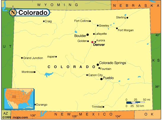 |
This Colorado base map highlights the location of the state capitol,
Denver, and
other major cities throughout the state. Portions of Colorado's border states,
Wyoming,
Nebraska,
Kansas,
Oklahoma,
New Mexico,
Arizona,
Nebraska, and
Utah are included to show the relationship between Colorado
and its neighbors. A small inset shows Colorado among the other 47 Continental United States.
The point where Utah, Colorado, New Mexico, and Arizona meet is called "Four Corners" and is unique among the states. |
| Colorado base map, Courtesy of Maps.com. |
|
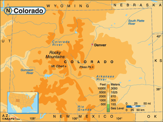
Colorado elevation map, Courtesy of Maps.com. |
This elevation map of Colorado illustrates the number of feet or meters the
state rises above sea level. As you can see, all of Colorado resides at over 2,000 feet above sea level.
The Great Plains cover the eastern 2/5 of the state. The Rocky Mountains run north to south
through the central part of the state.
At a mean elevation of 6,800 feet above seal level, Colorado has the highest mean altitude of the 50 states. Colorado's low point, 3,315 feet above sea level at the Arikaree River in Yuma County, is the highest low point in the nation and is higher than 18 state high points. The highest point in Colorado, Mount Elbert at 14,440 feet above sea level in Lake County, is also the highest point in the Rocky Mountains and the second highest point in the Continental United States. It's located in the Sawatch Range in the western-central part of the state about 20 miles east of Aspen. |
Additional information
Colorado maps: Additional maps and map links from NETSTATE.COM.
Colorado geography: More Colorado geography from NETSTATE.COM.
State elevations: State elevations listed by mean elevation, state high point and state low point.
Purchase Colorado maps:
Maps.com - The World's Largest Maps Store!
- Select map type by clicking on "category" to left on destination page.
- Use code NETSTATE at the checkout for 10% off orders of $50 or more!
- Over 6,000 products to choose from!
Site designed exclusively for NETSTATE.COM by NSTATE, LLC

NETSTATE.COM is a Trademark of NSTATE, LLC.
Copyright © © by NSTATE, LLC. All rights reserved.
No copyright is claimed on non-original or licensed material.
Support NETSTATE