
| Suggest a link | |
| Report broken link |


Delaware Base and Elevation Maps
The two maps shown here are digital base and elevation maps of Delaware. Higher resolution maps like
these and many other digital maps, wall maps, custom radius maps, travel maps, travel guides, map software, and globes and
games, for business and the classroom, are available to purchase from
Maps.com - The World's Largest Maps Store!.
Enter code "NETSTATE" at checkout for 10% off orders of $50 or more!
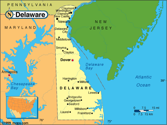 |
This Delaware base map highlights the location of the state capitol, Dover, and other major cities throughout the state. Portions of Delaware's border states, Pennsylvania and Maryland are included to show the relationship between Delaware and its neighbors. New Jersey lies to the east of Delaware on the opposite shores of the Delaware River and the Delaware Bay. A small inset shows a barely visible Delaware among the other 47 Continental United States. |
| Delaware base map, Courtesy of Maps.com. |
|
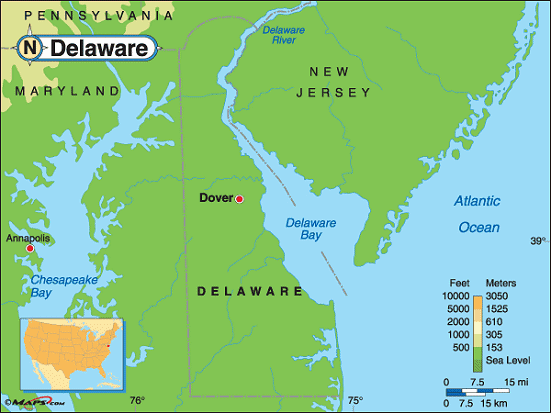
Delaware elevation map, Courtesy of Maps.com. |
This elevation map of Delaware illustrates the number of feet or meters the
state rises above sea level. As you can see, all of Delaware resides at less than 500 feet above sea level.
The lowest point in Delaware is sea level at the Atlantic Ocean. The highest point in Delaware, 450 feet above sea level, is located in the northern part of the state near the Pennsylvania border. The high point is located in a mobile home park west of Ebright Road, Wilmington, New Castle County. Some confusion may exist about the actual high point because of some ambiguous wording on a sign describing the Ebright Azimuth. |
There is a sign on Ebright Road, Wilmington, titled "Ebright Azimuth".
It states,
"The highest bench mark monument in Delaware is located on Ebright Road. This horizontal control mark denotes an elevation of 447.85 feet above sea level. The Delaware Geological Survey through its relationship with the National Geodetic Survey has determined that this bench mark monument is in the vicinity of the highest natural elevation in the state." Note the words, "in the vicinity." The actual geodetic marker is across the street and, it seems, the highest point is higher than 447.85 feet above sea level and is located some distance from the actual marker. According the William S. Schenck, Delaware Geological Survey of the University of Delaware, " Surveying by NGS and DGS personnel indicates that the mobile home park just west of Ebright Road is a least two feet higher than the benchmark. Therefore, according to scientists in the survey office, the highest actual elevation in Delaware is around 450 feet above sea level." |
|
Additional information
Delaware maps: Additional maps and map links from NETSTATE.COM.
Delaware geography: More Delaware geography from NETSTATE.COM.
State elevations: State elevations listed by mean elevation, state high point and state low point.
Purchase Delaware maps:
Maps.com - The World's Largest Maps Store!
- Select map type by clicking on "category" to left on destination page.
- Use code NETSTATE at the checkout for 10% off orders of $50 or more!
- Over 6,000 products to choose from!
Site designed exclusively for NETSTATE.COM by NSTATE, LLC

NETSTATE.COM is a Trademark of NSTATE, LLC.
Copyright © © by NSTATE, LLC. All rights reserved.
No copyright is claimed on non-original or licensed material.
Support NETSTATE