
-->
| Suggest a link | |
| Report broken link |


Michigan Base and Elevation Maps
The two maps shown here are digital base and elevation maps of Michigan. Higher resolution maps like
these and many other digital maps, wall maps, custom radius maps, travel maps, travel guides, map software, and globes and
games, for business and the classroom, are available to purchase from
Maps.com - The World's Largest Maps Store!.
Enter code "NETSTATE" at checkout for 10% off orders of $50 or more!
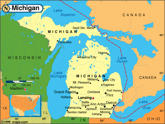 |
This Michigan base map highlights the location of the state capitol,
Lansing, and
major cities throughout the state. Portions of Michigan's border states,
Ohio,
Indiana,
and Wisconsin are
included to show the relationship between Michigan and its neighbors. A small inset shows Michigan among the
other 47 Continental United States.
Michigan also shares international borders with Canada. |
| Michigan base map, Courtesy of Maps.com. |
|
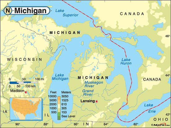
Michigan elevation map, Courtesy of Maps.com. |
This elevation map of Michigan illustrates the number of feet or meters the
state rises above sea level.
Unique among the states, Michigan is comprised of two peninsulas. The Upper Peninsula interjects itself into Lake Superior, Lake Huron and Lake Michigan. The Lower Peninsula is bordered by Lake Michigan, Lake Huron and Lake Erie in the south. As you can see, most of Michigan resides between 500 and 1,000 feet above sea level, though parts of each peninsula rise above 1,000 feet. The lowest point in Michigan is 571 feet above sea level at Lake Erie. The highest point in the state, Mount Arvon, rises 1,979 feet above sea level in the Huron Mountains of the Upper Peninsula. Located in Baraga County, it's about 90 miles northwest of Escanaba and about 12 miles east of L'Anse, Michigan. |
Additional information
Michigan maps: Additional maps and map links from NETSTATE.COM.
Michigan geography: More Michigan geography from NETSTATE.COM.
State elevations: State elevations listed by mean elevation, state high point and state low point.
Purchase Michigan maps:
Maps.com - The World's Largest Maps Store!
- Select map type by clicking on "category" to left on destination page.
- Use code NETSTATE at the checkout for 10% off orders of $50 or more!
- Over 6,000 products to choose from!
Site designed exclusively for NETSTATE.COM by NSTATE, LLC

NETSTATE.COM is a Trademark of NSTATE, LLC.
Copyright © © by NSTATE, LLC. All rights reserved.
No copyright is claimed on non-original or licensed material.
Support NETSTATE