 |
|||||||||||||
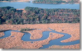
he Coastal Plain extends from the Fall Zone eastward to the Atlantic Ocean. Through the Fall Zone, the larger streams cascade off the resistant igneous and metamorphic rocks of the Piedmont to sea level. Large tidal rivers, the Potomac, Rappahannock, York, and James, flow southeastward across the Coastal Plain to the Chesapeake Bay. The Bay, in turn, empties into the Atlantic Ocean. The topography of the Coastal Plain is a terraced landscape that stair-steps down to the coast and to the major rivers. The risers (scarps) are former shorelines and the treads are emergent bay and river bottoms. The higher, older plains in the western part of the Coastal Plain are more dissected by stream erosion than the lower, younger terrace treads. This landscape was formed over the last few million years as sea level rose and fell in response to the repeated melting and growth of large continental glaciers and as the Coastal Plain slowly uplifted. During the glacial maxima, much of the continental shelf was emergent and the Susquehanna flowed through the Chesapeake lowland and across the exposed shelf to the sea 80 km or more to the east. The Chesapeake Bay was created about 5000 to 6000 years ago when the lower course of the Susquehanna River through the Chesapeake lowland was flooded as meltwater from the large Pleistocene continental glaciers raised sea level. Continuing sea level rise and shoreline erosion caused the bay to expand its aerial extent.
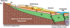
The Virginia Coastal Plain is underlain by a thick wedge of sediments
that increases in thickness from a featheredge near the Fall Zone
Latest Tertiary and Quaternary sand, silt, and clay, which cover much of the Coastal Plain, were deposited during interglacial highstands of the sea under conditions similar to those that exist in the modern Chesapeake Bay and its tidal tributaries.
|
|||||||||||||