
| Suggest a link | |
| Report broken link |


Alaska Base and Elevation Maps
The two maps shown here are digital base and elevation maps of Alaska. Higher resolution maps like
these and many other digital maps, wall maps, custom radius maps, travel maps, travel guides, map software, and globes and
games, for business and the classroom, are available to purchase from
Maps.com - The World's Largest Maps Store!.
Enter code "NETSTATE" at checkout for 10% off orders of $50 or more!
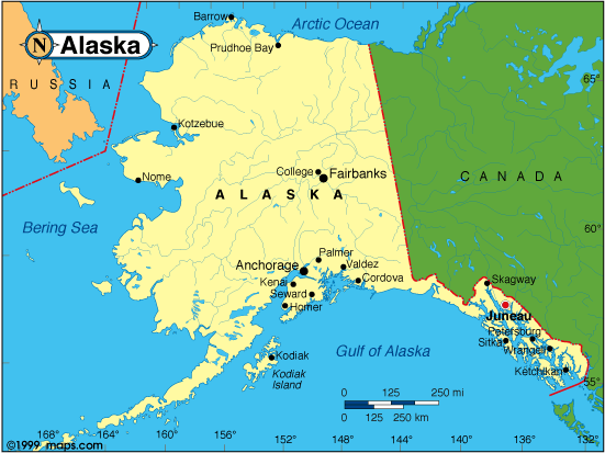 |
This Alaska base map highlights the location of the state capitol, Juneau, and other major cities throughout the state. Alaska is bordered on the north by the Arctic Ocean, on the south by the Gulf of Alaska, and on the west by the Bering Sea. On the east, Alaska is bordered by Canada. |
| Alaska base map, Courtesy of Maps.com. |
|
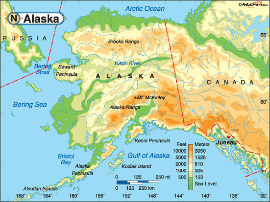
Alaska elevation map, Courtesy of Maps.com. |
This elevation map of Alaska illustrates the number of feet or meters the
state rises above sea level.
Alaska is surrounded on three sides by water. The lowest points in the state are at sea level where the land meets the Arctic Ocean, the Bering Sea, and Bristol Bay and the Gulf of Alaska of the North Pacific Ocean. The Brooks Range of mountains in the north and the Alaska Range in the south are clear as they cut from east to west across the state. The peak of Mount McKinley, also known as Denali, reaches 20,320 feet above sea level in the Alaska Range. It's the highest point in the United States. In fact, it's the highest point in North America. Mount McKinley is located in Denali National Park & Preserve about 130 miles northwest of Anchorage and about 155 miles southwest of Fairbanks. [ Topographic map | More ] |
Additional information
Alaska maps: Additional maps and map links from NETSTATE.COM.
Alaska geography: More Alaska geography from NETSTATE.COM.
State elevations: State elevations listed by mean elevation, state high point and state low point.
Purchase Alaska maps:
Maps.com - The World's Largest Maps Store!
- Select map type by clicking on "category" to left on destination page.
- Use code NETSTATE at the checkout for 10% off orders of $50 or more!
- Over 6,000 products to choose from!
Site designed exclusively for NETSTATE.COM by NSTATE, LLC

NETSTATE.COM is a Trademark of NSTATE, LLC.
Copyright © © by NSTATE, LLC. All rights reserved.
No copyright is claimed on non-original or licensed material.
Support NETSTATE