
| Suggest a link | |
| Report broken link |


Arkansas Base and Elevation Maps
The two maps shown here are digital base and elevation maps of Arkansas. Higher resolution maps like
these and many other digital maps, wall maps, custom radius maps, travel maps, travel guides, map software, and globes and
games, for business and the classroom, are available to purchase from
Maps.com - The World's Largest Maps Store!.
Enter code "NETSTATE" at checkout for 10% off orders of $50 or more!
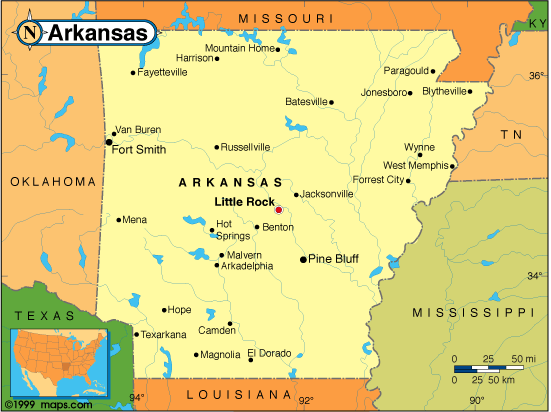 |
This Arkansas base map highlights the location of the state capitol, Little Rock, and other major cities throughout the state. Portions of Arkansas's border states, Missouri, Tennessee, Mississippi, Louisiana, Texas, and Oklahoma are included to show the relationship between Arkansas and its neighbors. A small inset shows the position of Arkansas among the other 47 Continental United States. |
| Arkansas base map, Courtesy of Maps.com. |
|
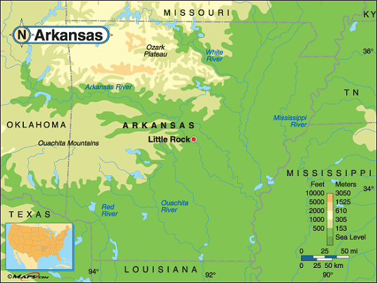
Arkansas elevation map, Courtesy of Maps.com. |
This elevation map of Arkansas illustrates the number of feet or meters the
state rises above sea level. As you can see, about 1/2 of Arkansas is around 500 feet above sea level. The land
rises to the west and the north.
The lowest point in Arkansas is 55 feet above sea level at the Ouachita River on the border of Union and Ashley Counties. The highest point in the state is located in the northwest part of the state, to the south of the Arkansas River. Signal Hill, (Mount Magazine) at 2,753 feet above sea level, is located in Logan County about 48 miles southeast of Fort Smith and about 90 miles northwest of Little Rock. The State of Arkansas has developed Mt. Magazine State Park on Ozark National Forest lands atop Mount Magazine. |
Additional information
Arkansas maps: Additional maps and map links from NETSTATE.COM.
Arkansas geography: More Arkansas geography from NETSTATE.COM.
State elevations: State elevations listed by mean elevation, state high point and state low point.
Purchase Alabama maps:
Maps.com - The World's Largest Maps Store!
- Select map type by clicking on "category" to left on destination page.
- Use code NETSTATE at the checkout for 10% off orders of $50 or more!
- Over 6,000 products to choose from!
Site designed exclusively for NETSTATE.COM by NSTATE, LLC

NETSTATE.COM is a Trademark of NSTATE, LLC.
Copyright © © by NSTATE, LLC. All rights reserved.
No copyright is claimed on non-original or licensed material.
Support NETSTATE