
| Suggest a link | |
| Report broken link |


Indiana Base and Elevation Maps
The two maps shown here are digital base and elevation maps of Indiana. Higher resolution maps like
these and many other digital maps, wall maps, custom radius maps, travel maps, travel guides, map software, and globes and
games, for business and the classroom, are available to purchase from
Maps.com - The World's Largest Maps Store!.
Enter code "NETSTATE" at checkout for 10% off orders of $50 or more!
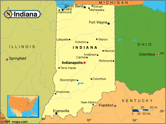 |
This Indiana base map highlights the location of the state capitol, Indianapolis, and other major cities throughout the state. Portions of Indiana's border states, Michigan, Ohio, Kentucky, and Illinois are included to show the relationship between Indiana and its neighbors. Indiana borders the southern end of Lake Michigan in the north. A small inset shows Indiana among the other 47 Continental United States. |
| Indiana base map, Courtesy of Maps.com. |
|
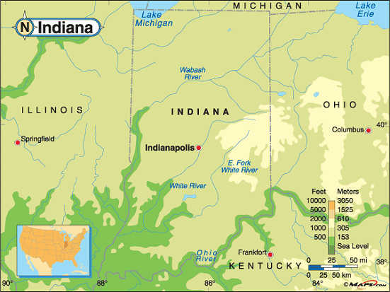
Indiana elevation map, Courtesy of Maps.com. |
This elevation map of Indiana illustrates the number of feet or meters the
state rises above sea level. With a
mean elevation of only
700 feet above sea level, Indiana is a relatively flat state.
Its lowest point is at the Ohio River in Posey County in the southwestern corner of the state. The Till Plains run in broad belt from east to west across the center of Indiana. Characterized by low hills and valleys, this part of the Midwestern "Corn Belt"1 is where the highest point in Indiana can be found. Rising to 1,257 feet above sea level, Hoosier Hill is located in the eastern part of the state, in Wayne County, near the Ohio border. Hoosier Hill is about 40 miles southeast of Muncie and about 10 1/2 miles north of Richmond. |
Additional information
Indiana maps: Additional maps and map links from NETSTATE.COM.
Indiana geography: More Indiana geography from NETSTATE.COM.
State elevations: State elevations listed by mean elevation, state high point and state low point.
Purchase Indiana maps:
Maps.com - The World's Largest Maps Store!
- Select map type by clicking on "category" to left on destination page.
- Use code NETSTATE at the checkout for 10% off orders of $50 or more!
- Over 6,000 products to choose from!
Site designed exclusively for NETSTATE.COM by NSTATE, LLC

NETSTATE.COM is a Trademark of NSTATE, LLC.
Copyright © © by NSTATE, LLC. All rights reserved.
No copyright is claimed on non-original or licensed material.
Support NETSTATE