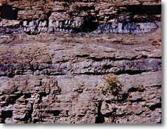
Coal seams exposed along Keen Mountain, Buchanan
County. Each seam is approximately 0.5 m.
|
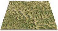
n Virginia, the southwestern portion of the state is part of the
Appalachian Plateau province. Regionally, the Appalachian Plateau lies to the northwest of
the Valley & Ridge. The boundary between the two
provinces, known as the Allegheny structural front in northern and central Virginia A, is a transition from tight folds of the Valley &
Ridge to low-amplitude folds and flat-lying rocks in the Plateau.
Although some parts of the Plateau exhibit a low relief plateau-like morphology much of the Appalachian Plateau is strongly
dissected by stream erosion
and the topography is rugged. Regional scale folds in the Plateau formed in
response to shortening on thrust faults that do not reach the present surface and are
rooted to the east in the Valley & Ridge province. The upper Paleozoic strata of the
Plateau are rich in mineral resources such as coal, natural gas, and petroleum.
|