|
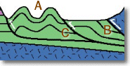
he Valley & Ridge province consists of elongate parallel ridges and
valleys that are underlain by folded Paleozoic
sedimentary rock  . The characteristic topography of this region is the result of
differential weathering of linear belts of rocks that have been repeated by folding and
faulting. Cambrian clastic sediments of the western Blue
Ridge are overlain by carbonates that made up the Great
American Bank. For at least 70 million years carbonates were deposited in a shallow
tropical ocean along the southeast edge of North America. Today these carbonates (up to
3.5 km in thickness) are exposed in the Great Valley (known as the Shenandoah Valley in
central and northern Virginia), the easternmost portion of the Valley & Ridge
province. Well-developed karst topography
is characteristic of the Great Valley and many caverns are located in the subsurface. . The characteristic topography of this region is the result of
differential weathering of linear belts of rocks that have been repeated by folding and
faulting. Cambrian clastic sediments of the western Blue
Ridge are overlain by carbonates that made up the Great
American Bank. For at least 70 million years carbonates were deposited in a shallow
tropical ocean along the southeast edge of North America. Today these carbonates (up to
3.5 km in thickness) are exposed in the Great Valley (known as the Shenandoah Valley in
central and northern Virginia), the easternmost portion of the Valley & Ridge
province. Well-developed karst topography
is characteristic of the Great Valley and many caverns are located in the subsurface.
|
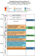
By middle Ordovician time, clastic sediments were shed from highlands
marking the onset of the Taconic orogeny. The Taconic orogeny uplifted
mountains to the east (in the Piedmont). Late Ordovician and
Silurian rocks of the Valley & Ridge record the uplift and subsequent erosion of the
Taconic Mountains. By the late Silurian carbonates were again being deposited in this
region. Deposition of sediments continued from the Silurian through the Carboniferous in
the foreland (i.e. the Valley & Ridge and Appalachian
Plateau) and record pulses of uplift & mountain building to the east. Continental
collision in the late Paleozoic produced a fold and thrust belt in
which the Blue Ridge was imbricated and thrust
northwestward over the Paleozoic cover rocks  . Paleozoic sedimentary rocks
of the Valley & Ridge were also folded and moved westward along thrust faults . Paleozoic sedimentary rocks
of the Valley & Ridge were also folded and moved westward along thrust faults  . The
Great Valley is underlain by a two-tier duplex in which the entire Cambro-Ordovician
sequence is repeated. Between 50 and 75% shortening occurred in western Virginia during
the late Paleozoic deformation event known as the Alleghanian orogeny. . The
Great Valley is underlain by a two-tier duplex in which the entire Cambro-Ordovician
sequence is repeated. Between 50 and 75% shortening occurred in western Virginia during
the late Paleozoic deformation event known as the Alleghanian orogeny.
 |
1,052 (11/4/98) |
|
|
|
|