
The Geography of Washington
Click here for a few definitions.
| Longitude / Latitude |
Longitude: 116° 57'W to 124° 48'W
Latitude: 45° 32'N to 49°N |
|
| Length x Width |
Washington is about 360 miles long and 240 miles wide. |
|
Geographic Center
Explanation |
The
geographic center
of Washington is located in Chelan County, 10 miles WSW of Wenatchee.
Longitude: 120° 16.1'W
Latitude: 47° 20.0' N |
|
| Borders |
Washington is bordered by Canada in the north and Oregon
in the south. On the east, Washington is bordered by Idaho and, on the
west, Washington is bordered by the Pacific Ocean. |
| Total Area |
Washington covers 71,303 square miles, making it the 18th largest of the
50 states. |
| Land Area |
66,582 square miles of Washington are land areas. |
| Water Area |
4,721 square miles of Washington are covered by water. |
| Highest Point |
The highest point in Washington is
Mt. Rainier
at 14,410 feet above sea level. |
| Lowest Point |
The lowest point in Washington is sea level where Washington meets
the Pacific Ocean in the west. |
| Mean Elevation |
The Mean Elevation of the state of Washington is 1,700 feet above sea level. |
| Major Rivers |
Columbia River, Snake River, Yakima River |
| Major Lakes |
Lake Franklin D. Roosevelt, Lake Washington |
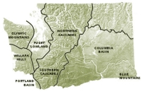
The Land |
| Washington, the only state named after a president, is located in the northwestern part of the
contiguous 48 states on the Pacific Ocean. The Evergreen State, the 18th largest state in the union,
can be divided into six geographic land areas; the Olympic Mountains, the Coast Range, the Puget Sound
Lowlands, the Cascade Mountains, the Columbia Plateau, and the Rocky Mountains.
Olympic Mountains: The
Olympic Mountains
in the northwest corner of Washington are bordered on the north by the Strait of Juan de Fuca and on the west by the
Pacific Ocean.
To the east of the Olympic Mountains lies
Puget Sound Lowlands
and to the south of the mountains is the Coast Range. The Olympic Mountains are wild areas indeed. Some areas are
thought to have never been explored. Most of this land area lies within the borders of
Olympic National Park.
Coast Range: To the south of the Olympic Mountains in the southwest corner of Washington is
the land area referred to as the Coast Range. The Coast Range runs south into Oregon. The most notable
features of the Coast Range in Washington are the
Willapa Hills
which overlook Willapa Bay.
Puget Sound Lowlands: To the east of the Olympic Mountains and the west of the Cascade Mountains,
Puget Bay extends south into Washington and north into British Columbia, Canada. The
Puget Sound Lowlands
also include the land along the Chehalis River that runs to the Pacific Ocean between the Olympic Mountains
in the north and the Willapa Hills in the south. This is the Valley of the Chehalis River. About 3/4 of
Washington's population live in the Puget Sound Lowlands. Most of the states cities, including
Tacoma
and the state capital,
Olympia
are located on the lowlands.
Puget Sound
is connected to the Pacific Ocean in the north by the Strait of Juan de Fuca
Cascade Mountains: To the east of the Puget Sound Lowlands the great
Cascade Mountains
rise high, several peaks extending more than 10,000 feet into the sky.
Mt. Rainier,
the highest point in Washington is located in the Cascade Mountains along with
Mount St. Helens
which errupted in 1980. This 700-mile chain of mountains is marked by several volcanic peaks, most of them
inactive. Besides
Mt. Rainier
(14,410 feet),
Mount Adams
(12,307 feet),
Mount Baker
(10,778 feet) and
Glacier Peak
(10,541 feet) are prominent in the Cascade Mountatin range. All of the higher mountains support glaciers and permanent snow
cover on their upper slopes. The lower slopes and lower mountains are carpeted with beautiful, lush forests,
most located within designated National Forest areas. Visit
Mt. Rainier National Park.
Columbia Plateau: Most of southern and central Washington is covered by the
Columbia Plateau
land area, also referred to as the Columbia Basin. This area is elevated from 500 to 2,000 feet above
sea level and surrounded by higher lands It's part of the largest lava plateau in the world. The Columbia
Plateau lies to the south and the east of the great bend in the Columbia River. Features of the Columbia
Plateau are described as "coulees" and "scablands."
Coulees
are dry canyons with steep walls cut into the lava thousands of years ago. When glaciers blocked the Columbia
River on its way to the Pacific, rushing water and ice cut trenches across the plateau. When the glaciers
melted and the Columbia River was free to fall into its present course, these rivers and streams dried up.
Grand Coulee and Moses Coulee are the most notable of these canyons. Scablands are patches of lava lying on
the surface of the plateau.
The Palouse country of Washington lies in the southeastern portion of the Columbia Plateau. The rolling hills of Palouse Country provide
a deep fertile soil that supports much of Washington's wheat farming.
The Blue Mountains lie in the deep southeastern corner of Washington. These mountains, lower than the Cascades or the Olympic Mountains,
provide land for hay and grains in the valleys and summer grazing for livestock on the slopes.
Rocky Mountains: A portion of the Rocky Mountains cuts across Washington in the northeast corner
of the state. The Washington Rocky Mountains are called the Columbia Mountains and consist of ridges and
valleys cut by the Columbia River and its tributaries including the Okanogan River. Minerals such as
copper, gold, lead, limestone, magnesite, silver and zinc are found in the Columbia Mountains.
( Washington Close-up ) |
| Climate (All temperatures Fahrenheit) |
| Highest Temperature |
The highest temperature recorded in Washington is 118°, Fahrenheit. This record high
was recorded on August 5, 1961 at Ice Harbor Dam. |
| Lowest Temperature |
The lowest temperature in Washington, -48°, was recorded on December 30, 1968 at Mazama and Winthrop. |
| Average Temperature |
Monthly average temperatures range from a high of 84.0 degrees to a low of 20.0 degrees. |
| Climate |
Washington's climate varies greatly from west to east. A mild, humid climate predominates in the western
part of the state, and a cooler dry climate prevails east of the Cascade Range. The average annual temperature
ranges from 10.6° C (51° F) on the Pacific coast to 4.4° C (40° F) in the northeast. The recorded temperature
in the state has ranged from -44.4° C (-48° F) in 1968 to 47.8° C (118° F) in 1961. A wet marine West Coast
climate predominates in western Washington; it is mild for its latitude due to the presence of the warm North
Pacific Current offshore and the relatively warm maritime air masses. The region has frequent cloud cover,
considerable fog, and long-lasting drizzles; summer is the sunniest season. The western side of the Olympic
Peninsula receives as much as 4064 mm (160 in) of precipitation annually, making it the wettest area of the
48 conterminous states. Weeks or even months, may pass without a clear day. Portions of the Puget Sound area,
on the leeward side of the Olympic Mountains, are less wet, although still humid. The western slopes of the
Cascade Range receive some of the heaviest annual snowfall (in some places more than 5080 mm/200 in) in the
country. In the rain shadow east of the Cascades the annual precipitation is only 152 mm (6 in). Precipitation
increases eastward toward the Rocky Mountains, however.
Average yearly precipitation for Washington, from 1971 to 2000, is shown on
this chart from Oregon State University.
Source: Access Washington, (http://access.wa.gov/government/awgeneral.asp#geo), March 13, 2002 |
|


;)