
HOME
INTRO
SYMBOLS
ALMANAC
ECONOMY
GEOGRAPHY
STATE MAPS
PEOPLE
COUNTIES
GOVERNMENT
FORUM
NEWS
COOL SCHOOLS
STATE QUIZ
STATE LINKS
BOOK STORE
MARKETPLACE
NETSTATE.STORE
NETSTATE.MALL
GUESTBOOK
CONTACT US


Tweet
Double click on word for definition.
Autauga County Location
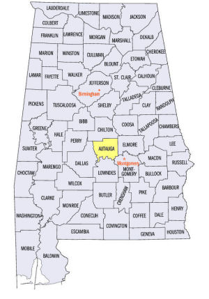
This map shows the location of Autauga County within the State of Alabama.
Autauga is located in central Alabama within the East Gulf Coastal Plain physiographic region, northwest of the state capital, Montgomery. The Alabama River runs along its southern border.
Created from a part of Montgomery County, Autauga County was established by an Act of the Alabama Territorial Legislature on November 21, 1818, before Alabama achieved statehood.
According to the Prattville Daughters of the Revolution (DAR), "Autauga County takes its name from the Indian village Atagi, which means 'pure water'. Atagi was located on the north side of the Alabama River, at the junction of the river and Autauga Creek."
Other sources claim the county was named for Autauga Creek or the Autauga Indians. Because Autauga is a derivative form of, or comes from, Atagi, we favor the DAR's explanation.
The people who lived in Adagi were members of the Alibamu tribe and members of the Muscogee (Creek) confederacy.
Jackson's Mill served as an initial county seat, but the seat was quickly moved to Washington. In 1830, the county seat was moved to more centrally located Kinston. The seat was moved again, in 1868, to the more populated city of Prattville, in the southeastern part of the county. Prattville continues to serve as the county seat today.
At a glance
| Point | Fact |
|---|---|
| Established: | November 21, 1818 |
| Source: | Created from a part of Montgomery County. |
| Area (square miles): | 595 |
| Population (2010 census): | 54,571 |
| Major waterway(s): | The Alabama River runs along Autauga County's southern border. |
| Major highway(s): | Interstate 65 is a major north-south transportation route in eastern Autauga County. U.S. Route 31 runs north-south next to I-65. U.S. Route 82 runs northwest-southeast. State Route 14, the Selma Highway, runs east-west in southern Autauga County. |
| County seat: | Prattville |
| Largest city: | Prattville |
Sources...
"Alabama Counties: Autauga County." Alabama Department of Archives and History. State of Alabama, 25 Oct 2011. Web. 5 Jan 2014. <http://www.archives.state.al.us/counties/autauga.html>.
Morton, Patricia Hoskins. "Alabama Counties: Autauga County." Encyclopedia of Alabama. Alabama Humanities Foundation, 29 Mar 2013. Web. 5 Jan 2014. <http://www.encyclopediaofalabama.org/face/Article.jsp?id=h-1073>.
"State & County QuickFacts." United States Census Bureau. United States Department of Commerce. Web. 3 Jan 2014.
Additional Information
View Larger Map
Autauga County history page: Alabama Department of Archives and History.
Autauga County: The Encyclopedia of Alabama TM & © 2013. Alabama Humanities Foundation. All Rights Reserved. A service of Auburn University, The University of Alabama, and Alabama State Dept. of Education.
Map: Autauga County's major roads and towns. :
Prepared by the Department of Geography, College of Arts and Sciences, The University of Alabama.
:
Prepared by the Department of Geography, College of Arts and Sciences, The University of Alabama.
Autauga County: Major roads and towns:
Cartographic Research Lab, University of Alabama.
General Highway Map: Autauga County, Alabama:
Prepared by the Alabama Department of Transportation, Bureau of Transportation Planning, Surveying and Mapping Division in cooperation with the U.S. Department of Transportation.
Autauga County, Alabama Genealogical Information: The USGenWeb Project: Keeping Internet Genealogy Free.
Autauga County, Alabama: United States Census Bureau: State & County QuickFacts.
Autauga County: National Association of Counties (NACO).
Autauga County: Home: Official website of Autauga County, Alabama.
Prattville: The Encyclopedia of Alabama TM & © 2013. Alabama Humanities Foundation. All Rights Reserved. A service of Auburn University, The University of Alabama, and Alabama State Dept. of Education.
Prattville, Alabama: Official Site of the City of Prattville.
Alabama County Web Sites: State of Alabama: Alabama Directory.
Alabama County Selection Map: United States Census Bureau: State & County QuickFacts.
Alabama County Map with County Seat Cities: Geology.com.
Maps of Alabama Counties: University of Alabama: Alabama Maps.
Alabama Counties from Amazon.com
Autauga County
Daniel S. Gray
Autauga County: The First Hundred Years, 1818-1918, by Daniel S. Gray. 181 pages. Publisher: Autauga County Prattville Public Library 1972
DDD
Old Autauga
Larry W. Nobles
Old Autauga: Portrait of a Deep South County, by Larry W. Nobles. 379 pages. Cahaba Trace Commission (2000)
Old Autauga County was that greater portion of land area lying between 32 degree 19' and 32 degree 43' of north latitude and 86 degree 26' and 86 degree 53' of west longitude. Being situated between these parallels of latitude and meridinas of longitude set a geological stage where moonlight and magnolia with the help of slave labor would conquer the low lands, where yeomen farmers wsould triumph over the primeval wilderness and where a floursihing agronomy would coexist with industrial revolution.
Prattville
Marc Parker
Melissa Benefield Parker
Prattville, Alabama: A Brief History of the Fountain City, by Marc Parker, Melissa Benefield Parker. 192 pages. Publisher: The History Press (November 14, 2012)
In 1833, a New Hampshire industrialist named Daniel Pratt moved south. Pratt established the largest cotton gin factory in the world and, with it, a town known fittingly as Prattville. Soon this humble hamlet outside Montgomery became an industrial hub, fueling Alabama's antebellum cotton production. Through floods, tornadoes, damaging fires and shifting economic conditions, Prattville and its townspeople endured.
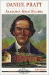
Daniel Pratt
Tom Bailey
Daniel Pratt: Alabama's Great Builder , by Tom Bailey. 112 pages. Publisher: Seacoast Publishing, Inc. (2002)
In this short biography, Tom Bailey portrays Alabama as a rugged and dangerous frontier when New Hampshirite Daniel Pratt arrived in 1833. In that year, Daniel Pratt came down the Federal Road into Alabama with a wagonload of machine parts, began building cotton gins and started changing the way people in Alabama made their livings.
Known as Alabama's first industrialist, Daniel Pratt founded Prattville, the county seat of Autauga County, and was also instrumental in establishing Pratt City in Jefferson County.


