
HOME
INTRO
SYMBOLS
ALMANAC
ECONOMY
GEOGRAPHY
STATE MAPS
PEOPLE
COUNTIES
GOVERNMENT
FORUM
NEWS
COOL SCHOOLS
STATE QUIZ
STATE LINKS
BOOK STORE
MARKETPLACE
NETSTATE.STORE
NETSTATE.MALL
GUESTBOOK
CONTACT US


Tweet
Double click on word for definition.
Baldwin County Location
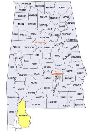
The map to the right shows the location of Baldwin County within the State of Alabama.
Baldwin County is located in southern Alabama on the Gulf of Mexico. It lies within the East Gulf Coastal Plain physiographic region of the state. The Tensaw River forms the western border of the county, running into the Mobile Bay.
Baldwin County is the largest county in Alabama at 1,589.78 square miles.
Present-day Alabama was part of the Mississippi Territory until 1817. Baldwin County was established by an Act of the "Mississippi" Territorial Legislature on December 21, 1809, almost ten years before Alabama became a state.
Ironically, the county was named for Abraham Baldwin, a distinguished citizen of Georgia, born in Connecticut, and educated at Yale College (theology) prior to the Revolutionary War. The name was suggested by settlers who had migrated from Georgia. [ Origin & Name ]
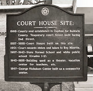
Daphne Court House Site Marker
Roads Less Traveled:
Exploring America's Past on Its Back Roads
In 1809, MacIntosh Bluff, now located in Mobile County, on the Tombigbee River in the northwest corner of the county served as county seat, but not for long. In 1810, the seat was moved south to Blakeley on the Tensaw River and there it rested until 1898, when the Alabama Legislature moved the seat further south to Daphne on Mobile Bay.
Two years later, in 1900, the Alabama Legislature officially named Bay Minette, in north central Baldwin County the county seat.
The citizens of Daphne were not happy with the loss of status, however, and refused to turn the county records over to the leaders of Bay Minette. After an unfavorable ruling by the State Supreme Court, Daphne remained intransigent. What happened on the night of October 10-11, 1901? Or, was it more like this?
Bay Minette currently serves as the county seat of Baldwin County.
At a glance
| Point | Fact |
|---|---|
| Established: | December 21, 1809 |
| Source: | Created from part of Washington County. |
| Area (square miles): | 1,596 |
| Population (2010 census): | 182,265 |
| Major waterway(s): | The southern edge of Baldwin County lies on the Gulf of Mexico. The Tensaw River forms the western boundary of the county, emptying into Mobile Bay. Bon Secour Bay, the final destination of the Bon Secour River, sits along the Alabama coast on the eastern edge of Mobile Bay. |
| Major highway(s): | Interstate 10 runs east-west south of center Baldwin County and Interstate 65 runs north-south north of center Baldwin County. They are Baldwin's major transportation routes. Other major routes are U.S Route 31, following I 65 into the county on its eastern border, but veering sharply south, U.S. Route 90, running east-west south of Interstate 10, and U.S. Route 98, running east-west through the southern part of the county then turning north to run parallel to Mobile Bay. |
| County seat: | Bay Minette |
| Largest city: | Fairhope |
Sources...
Brewer, David A. Z., Nick Warren, and Charissa D. Thomas Thomas. "Various Historical Compilations about Baldwin County, Alabama." Baldwin County, Alabama. Baldwin County, Alabama. Web. 6 Jan 2014. <http://www.baldwincountyal.gov/PageView.asp?PageType=R&edit_id=156>.
"Alabama Counties: Baldwin County." Alabama Department of Archives and History. State of Alabama, 25 Oct 2011. Web. 6 Jan 2014. <http://www.archives.state.al.us/counties/baldwin.html>.
Morton, Patricia Hoskins. "Alabama Counties: Baldwin County." Encyclopedia of Alabama. Alabama Humanities Foundation, 26 Mar 2013. Web. 6 Jan 2014. <http://www.encyclopediaofalabama.org/face/Article.jsp?id=h-1303>.
"State & County QuickFacts." United States Census Bureau. United States Department of Commerce. Web. 3 Jan 2014.
Additional Information
View Larger Map
Baldwin County history page: Alabama Department of Archives and History.
Baldwin County: The Encyclopedia of Alabama TM & © 2013. Alabama Humanities Foundation. All Rights Reserved. A service of Auburn University, The University of Alabama, and Alabama State Dept. of Education.
Map: Baldwin County's major roads and towns. :
Prepared by the Department of Geography, College of Arts and Sciences, The University of Alabama.
:
Prepared by the Department of Geography, College of Arts and Sciences, The University of Alabama.
Baldwin County Map:
Cartographic Research Lab, University of Alabama.
General Highway Map: Baldwin County, Alabama:
Prepared by the Alabama Department of Transportation, Bureau of Transportation Planning, Surveying and Mapping Division in cooperation with the U.S. Department of Transportation.
Baldwin County, Alabama Genealogical Information: The USGenWeb Project: Keeping Internet Genealogy Free.
Baldwin County, Alabama: United States Census Bureau: State & County QuickFacts.
Baldwin County: National Association of Counties (NACO).
Baldwin County, Alabama: Official website of Baldwin County, Alabama.
Bay Minette: The Encyclopedia of Alabama TM & © 2013. Alabama Humanities Foundation. All Rights Reserved. A service of Auburn University, The University of Alabama, and Alabama State Dept. of Education.
City of Bay Minette, Alabama: Official Site of the City of Bay Minette.
Alabama County Web Sites: State of Alabama: Alabama Directory.
Alabama County Selection Map: United States Census Bureau: State & County QuickFacts.
Alabama County Map with County Seat Cities: Geology.com.
Maps of Alabama Counties: University of Alabama: Alabama Maps.
Alabama Counties from Amazon.com
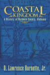
Coastal Kingdom
O. Lawrence Burnette
Coastal Kingdom: A History of Baldwin County, Alabama, by O. Lawrence Burnette. 434 pages. Publisher: PublishAmerica (October 30, 2006)
The section of the Gulf Coast lying between Perdido and Mobile bays has had a long and significant history of almost five hundred years, and the flags of Spain, France, Great Britain, the United States, Alabama, the Confederacy, and of a Naval Commander Ashore have marked the succession of powers that have exercised sovereignty over the area. Once one of the most remote and unsettled areas in North America, it has become a dynamic, rapidly-growing area, truly a “kingdom by the sea.” This is the story of Baldwin County, Alabama. The largest of Alabama’s counties, and older than the state itself, Baldwin provides an interesting case study of the evolution of a distinctive society and culture.
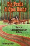
Pig Trails
& Open Roads
Jeanette Dyess Ryan
Pig Trails & Open Roads: Stories of Central Baldwin County, Alabama, by Jeanette Dyess Ryan. 296 pages. Publisher: iUniverse.com (January 21, 2009)
Resident and author Jeanette Dyess Ryan, invites you to come sit in the backyard swing and reminisce over this historical collection of stories and photographs from an era when life in Central Baldwin was simple and uncomplicated. It relives the vision of the early settlers who came by pig trail roads and trains to this remote area of virgin timber and wilderness.
From pioneer doctors to former mayors, outstanding principals and teachers, businessmen, and local people who made a difference, the stories paint a vivid picture of this vibrant community.
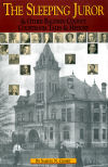
The Sleeping Juror
Samuel N. Crosby
The Sleeping Juror & Other Baldwin County Courtroom Tales & History, by Samuel N. Crosby. 152 pages. Publisher: Alabama Law Foundation (2002)
In The Sleeping Juror, Sam Crosby provides not only an invaluable historical record of the courts of Baldwin County, Alabama, but a tale of hilarious antics that have taken place in those courts.
The judges and attorneys, both famous and infamous, who have made their appearance in Baldwin County over the years are in evidence here, making Crosby's well-researched account a must-read for local history buffs and collectors of courtroom humor both in the county and throughout the state.


