Return to NETSTATE.COM home page.

|| HOME
|| INTRO
|| SYMBOLS
|| ALMANAC
|| ECONOMY
|| GEOGRAPHY
|| STATE MAPS
|| PEOPLE
|| FORUM
|| NEWS
|| COOL SCHOOLS
|| STATE QUIZ
|| BOOK STORE
|| MARKETPLACE
|| STATE LINKS
|| GUESTBOOK
|| CONTACT US

Idaho State Flag Idaho

Bookmark and Share

The Geography of Idaho

Click here  for a few definitions.

Longitude / Latitude Longitude: 111° W to 117° W
Latitude: 42° N to 49° N
Idaho map
Idaho base and elevation maps
Length x Width Idaho is 479 miles long and 305 miles wide.
Geographic Center
Explanation
The geographic center of Idaho is located in Custer County, on the Yankee Fork River, southwest of Challis.
Longitude: 114° 57.4'W
Latitude: 44° 15.4'N
Borders In the north, Idaho shares an international border with Canada. In the south, Idaho borders Nevada and Utah. Idaho is bordered by Montana and Wyoming on the east and by Washington and Oregon on the west.
Total Area Idaho covers 83,574 square miles, making it the 14th largest of the 50 states.
Land Area 82,751 square miles of Idaho are land areas.
Water Area 823 square miles of Idaho are covered by water.
Highest Point The highest point in Idaho is Borah Peak at 12,662 feet above sea level.
Lowest Point The lowest point in Idaho is only 710 feet above sea level; the Snake River in the northwestern part of the state near Lewiston.
Mean Elevation The Mean Elevation of the state of Idaho is 5,000 feet above sea level.
Major Rivers Coeur d'Alene River, Snake River, St. Joe River, St. Maries River, Kootenai River
Major Lakes Lake Pend Oreille, American Falls Reservoir, Bear Lake, Coeur d'Alene Lake

The Land

Idaho landscape
Courtesy: Access Idaho
Click for larger image.
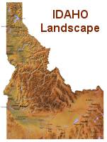
With 80 recognized mountain ranges, Idaho is home to some of the most spectacular scenery and most rugged landscapes in the United States. Dominated by the Rocky Mountains, Idaho's Shoshone Falls on the Snake River, drops 212 feet making it higher than Niagara Falls. Hells Canyon, also on the Snake River, is a gorge that is deeper than the Grand Canyon.  More about Shoshone Falls.

Idaho can be divided into three major land regions geographically; the Rocky Mountains, the Columbia Plateau and the Basin and Ridge Region.

Rocky Mountains: The Rocky Mountains area is the state's largest area and extends from the Idaho Panhandle (That's the narrow strip of Idaho that runs between Washington and Montana and borders Canada.) south and along the Wyoming border. The Rocky Mountains area is characterized by steep gorges, deep canyons and swift streams and rivers. Idaho has 50 mountain peaks that climb into the sky over 10,000 feet. Borah Peak, Idaho's highest point rises 12,662 feet above sea level.

The Bitterroot Mountain Range lies along the Montana border in the Idaho Panhandle. The Continental Divide passes through Idaho in the Bitterroots. Visit the Bitterroot National Forest.

The Coeur d'Alene Mountains in the northern Panhandle lie to the west of the Bitterroot Mountain Range. This triangular area of mountains stretches from Lake Pend Orielle in the north to Coeur d'Alene Lake in the south. The highest peak in the Coeur d'Alene Mountains is Grizzly Mountain at 5, 950 feet.

South of the Coeur d'Alene Mountains are the Clearwater Mountains and south of the Clearwater Mountains are the Salmon River Mountains. The Bighorn Crags, bare granite worn into sharp ridges and spires, are found in the Salmon River Mountains. This mountain range is almost completely circled by the Salmon River.

South of the Salmon River Mountains are the impressive Sawtooth Mountains; an extremely rugged series of granite peaks and beautiful meadows and alpine lakes. 33 mountains in this range exceed 10,000 feet above sea level.

The Seven Devils Mountains rise along Idaho's border with Oregon in the west. To the west of the Seven Devils Mountains, lies the Snake River and Hells Canyon. From the summits of the Seven Devils Mountains to the bed of the Snake River, the deepest gorge in North America is over 7,800 feet, deeper than the Grand Canyon.

In central Idaho, the Lost River Range extends 70 miles, northwest to southeast, from the Salmon River almost to Arco. It's bordered on the west by the Big Lost River Valley and the Salmon River and on the east by the Little Lost River and Pahsimeroi Valleys. The Lost River Range is a vast wilderness of snow-capped peaks and home to Borah Peak, Idaho's highest mountain as well as six other 12,000 foot peaks.

The Lemhi Range runs in a southeasterly direction about 100 miles from the Salmon River to the Snake River Plains. This chain of mountains is from 10 to 15 miles wide. The Lemhi Range is bordered on the west by Pahsimeroi and Little Lost River valleys and on the east by the Lemhi and Birch Creek Valleys. The highest point in the Lemhi Range is Diamond Peak at 12,197 above sea level.

Further south, the Blackfoot Mountains form a group of barren ridges that trend from northwest to southeast for more than 50 miles between Idaho Falls and Soda Springs. From the west, slopes of the Blackfoot Mountains climb roughly 2,400 feet above the Snake River. On the east, the slopes rise only 600 feet above Willow Creek and the Blackfoot River. Blackfoot Peak is the highest point in this range at 7, 404 feet. Wolverine Canyon, a scenic gorge, is on the western slope of the Blackfoot Mountains.

Columbia Plateau
The Columbia Plateau
Courtesy: U.S. Geological Survey
Columbia Plateau: The Columbia Plateau Sweeps out of Washington, into Idaho at the base of the Idaho Panhandle, and follows the Snake River across southern Idaho. The Snake River Plain, built up of lava flows, covers strips of land 20 to 40 miles wide on each side of the Snake River. Potatoes and Sugar Beets, Idaho's leading crops are grown on the Snake River Plain.

Basin and Range Region: This land area lies in southeastern Idaho along. A part of the Rocky Mountain region lies to the east of the Basin and Range Region. This area is characterized by grassy plateaus and deep valleys in the mountainous sections.

( Idaho Close-up )

Climate (All temperatures Fahrenheit)
Highest Temperature The highest temperature recorded in Idaho is 118°, Fahrenheit. This record high was recorded on July 28, 1934 at Orofino.
Lowest Temperature The lowest temperature in Idaho, a very chilly -60°, was recorded on January 16, 1943 at Island Park Dam.
Average Temperature Monthly average temperatures range from a high of 90.6 degrees to a low of 15.1 degrees.
Climate Idahos climate is diverse. It is influenced by Pacific weather patterns, which help moderate temperature extremes. Generally, the northern part of the state has greater precipitation than either southwestern or southeastern Idaho. The southern part of the state has warmer summer temperatures than the north and is drier throughout the year. Southeastern Idaho, however, tends to be cooler than the west and drier than the north. Idahos growing season varies from about 200 days near the city of Lewiston to very brief at high altitudes. Idaho has no hurricanes and tornadoes are extremely rare. Winds may accompany cold fronts and thunderstorms, but hail damage in the state is very small compared to that which occurs in the central United States.

Average yearly precipitation for Idaho, from 1971 to 2000, is shown on this chart from Oregon State University.

Geographically representative climate examples are:
Elevation Annual Mean
Precipitation
Mean
Snowfall
July Avg
High Temp
Jan Avg
Low Temp
July Avg
PM Humidity
Boise 2,840 12.0 in. 21.3 in. 90.5 21.2 22%
Coeur dAlene 2,160 25.7 in. 52.2 in. 85.1 22.3 34%
Idaho Falls 4,730 10.9 in. 37.5 in. 86.0 10.0 25%
Lewiston 1,440 12.4 in. 19.8 in. 89.0 27.1 34%
Pocatello 4,450 12.2 in. 47.2 in. 88.0 14.4 38%
Twin Falls 3,960 10.5 in. 31.3 in. 85.0 19.0 27%
All temperatures given in Fahrenheit
Sources:
The World Almanac of the U.S.A. by Allan Carpenter and Carl Provorse, Copyright © 1998
Harley Johansen and Ronald L. Hatzenbuehler, "Idaho," World Book Online Americas Edition, http://www.worldbookonline.com/wbol/wbPage/na/ar/co/271480, Sept 5, 2001.
Idaho Department of Commerce, Idaho at a Glance, 2000
The United States Geological Survey, http://www.usgs.gov
Maps.com http://www.maps.com
To Hawaii geography. To Illinois geography.

[ HOME || INTRO || SYMBOLS || ALMANAC || ECONOMY || GEOGRAPHY || STATE MAPS || PEOPLE ]
[ FORUM || NEWS || COOL SCHOOLS || STATE QUIZ || BOOK STORE || MARKETPLACE || STATE LINKS ]
|| GUESTBOOK || CONTACT US || PRIVACY STATEMENT ]

Site designed exclusively for NETSTATE.COM by NSTATE
United States Flag


NETSTATE.COM is a Trademark of NSTATE, LLC.
Copyright © 2001- by NSTATE, LLC. All rights reserved.
No copyright is claimed on non-original or licensed material.
Support NETSTATE

Top