Return to NETSTATE.COM home page.

|| HOME
|| INTRO
|| SYMBOLS
|| ALMANAC
|| ECONOMY
|| GEOGRAPHY
|| STATE MAPS
|| PEOPLE
|| FORUM
|| NEWS
|| COOL SCHOOLS
|| STATE QUIZ
|| BOOK STORE
|| MARKETPLACE
|| STATE LINKS
|| GUESTBOOK
|| CONTACT US

Utah State Flag Utah

Bookmark and Share

The Geography of Utah

Click here  for a few definitions.

Longitude / Latitude Longitude: 109°W to 114°W
Latitude: 37°N to 42°N
Utah map
Utah base and elevation maps
Length x Width Utah is about 350 miles long and 270 miles wide.  
Geographic Center
Explanation
The geographic center of Utah is located in Sanpete County, 3 miles north of Manti.
Longitude: 111° 41.1'W
Latitude: 39° 23.2'N
 
Borders Utah is bordered by Idaho and Wyoming on the north and by Arizona on the south. On the east, Utah is bordered by Colorado. On the west, Utah is bordered by Nevada.
Total Area Utah covers 84,904 square miles, making it the 13th largest of the 50 states.
Land Area 82,168 square miles of Utah are land areas.
Water Area 2,736 square miles of Utah are covered by water.
Highest Point The highest point in Utah is Kings Peak at 13,528 feet above sea level.
Lowest Point The lowest point in Utah is Beaverdam Wash at 2,000 feet above sea level.
Mean Elevation One of the three highest states in the union, the Mean Elevation of the state of Utah is 6,100 feet above sea level.
Major Rivers Colorado River, Green River
Major Lakes Great Salt Lake, Lake Powell, Utah Lake

The Land

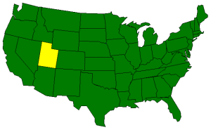
Located in the Rocky Mountain Region of the United States, Utah is a land of snow-covered peaks, natural rock formations, and beautifully colored canyons. Utah's geography is characterized by three major land areas; the Rocky Mountains, the Basin and Ridge Region, and the Colorado Plateau.

Rocky Mountains: Running north to south through the United States, the Rocky Mountians are an imposing presence in many of the western states. In Utah, two ranges of the Rockies extend through the northeast corner of the state; the Uinta Range and the Wasatch Range.

The Uinta Range extends from Colorado in the east almost all of the way to Salt Lake City in north central Utah. It is the only range of the Rocky Mountains that runs east and west. Lakes and flat-bottomed canyons, formed by glacial activity, are interspersed with mountains that reach over 13,000 feet above sea level. Kings Peak, the highest point (13,528 feet above sea level) in Utah, is found in the Uinta Range.

The Wasatch Range stretches from Mount Nebo in north central Utah northward into Idaho. On the west, the mountains range from 6,000 to 8,000 feet above sea level.

Basin and Ridge Region: One of the driest areas of the United States, the Basin and Ridge Region covers parts of several states, including Utah. The Basin and Ridge Region of Utah, which spreads over the western part of the state, is covered by small mountains and basins except on the east and west edges where the mountains are higher. Great Salt Lake is located in the northeastern corner of the Basin and Ridge Region with the Great Salt Lake Desert to the west and southwest of the lake. About 4,000 acres of hard flat salt beds are found in the center of the Great Salt Lake Desert; Bonneville Salt Flats. The Bonneville Salt Flats are named after the ancient sea that covered the area, Lake Bonneville.

"Utah's Dixie" is located in the extreme southwestern corner of the Basin and Ridge Region. This area is the warmest and the lowest part of the state.
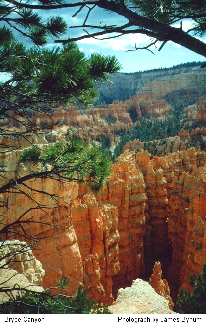
Click for larger image, Copyright ©  by James Bynum.
Bryce Canyon
Photograph by James Bynum
Colorado Plateau: The Colorado Plateau covers most of the southern and eastern areas of Utah. The area is characterized by broad high country cut by deep canyons and valleys. The western part of the region is comprised of high plateaus such as Aquarius, Fish Lake, and Markagunt. These plateaus are more than 11,000 feet above sea level. Famous Bryce Canyon, Cedar Breaks Canyon, and Zion Canyon are found in the Colorado Plateau area. The Colorado River passes through Utah in the east with the Henry Mountains on the west banks of the river and the Abajo and La Sal mountains to the east of the river.

Utah's southeastern corner meets the corners of Arizona, New Mexico, and Colorado. Referred to as "Four Corners," this is the only place in the United States where four states meet.

( Utah Close-up )


Climate (All temperatures Fahrenheit)
Highest Temperature The highest temperature recorded in Utah is 117°, Fahrenheit. This record high was recorded on July 5, 1985 at Saint George.
Lowest Temperature The lowest temperature in Utah, -69°, was recorded on February 1, 1985 at Peter's Sink.
Average Temperature Monthly average temperatures range from a high of 93.2 degrees to a low of 19.7 degrees.
Climate Average yearly precipitation for Utah, from 1971 to 2000, is shown on this chart from Oregon State University.
Sources:
The World Almanac of the U.S.A. by Allan Carpenter and Carl Provorse, Copyright © 1998
George F. Hepner and Thomas G. Alexander, "Utah," World Book Online Americas Edition, http://www.worldbookonline.com/wbol/wbPage/na/ar/co/578420, August 15, 2001.
The United States Geological Survey Website
Maps.com http://www.maps.com
To Texas geography. To Vermont geography.

[ HOME || INTRO || SYMBOLS || ALMANAC || ECONOMY || GEOGRAPHY || STATE MAPS || PEOPLE ]
[ FORUM || NEWS || COOL SCHOOLS || STATE QUIZ || BOOK STORE || MARKETPLACE || STATE LINKS ]
|| GUESTBOOK || CONTACT US || PRIVACY STATEMENT ]

Site designed exclusively for NETSTATE.COM by NSTATE
United States Flag


NETSTATE.COM is a Trademark of NSTATE, LLC.
Copyright © 2001- by NSTATE, LLC. All rights reserved.
No copyright is claimed on non-original or licensed material.
Support NETSTATE

Top