
| Suggest a link | |
| Report broken link |


Minnesota Base and Elevation Maps
The two maps shown here are digital base and elevation maps of Minnesota. Higher resolution maps like
these and many other digital maps, wall maps, custom radius maps, travel maps, travel guides, map software, and globes and
games, for business and the classroom, are available to purchase from
Maps.com - The World's Largest Maps Store!.
Enter code "NETSTATE" at checkout for 10% off orders of $50 or more!
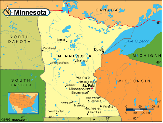 |
This Minnesota base map highlights the location of the state capitol,
St. Paul, and
major cities throughout the state. Portions of Minnesota's border states,
Wisconsin,
Iowa,
South Dakota, and
North Dakota are
included to show the relationship between Minnesota and its neighbors. A small inset shows Minnesota among the
other 47 Continental United States.
Minnesota also shares an international border with Canada on the north. |
| Minnesota base map, Courtesy of Maps.com. |
|
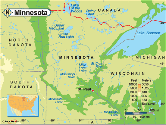
Minnesota elevation map, Courtesy of Maps.com. |
This elevation map of Minnesota illustrates the number of feet or meters the
state rises above sea level. As you can see, most of Minnesota rises over 1,000 feet above sea level, with
portions along the Red River, on Minnesota's western border, the Minnesota River, in southern Minnesota, and
the St. Croix and Mississippi Rivers that run along the state's eastern boundary with
Wisconsin falling below 1,000 feet above sea level.
The lowest point in the state is at the shoreline of Lake Superior (602 feet above sea level). The highest point in Minnesota is Eagle Mountain, located in Cook County, in northeast Minnesota, about 20 miles northwest of Grand Marais. Just south of Mound Lake, Eagle Mountain reaches 2,301 feet above sea level. [ Topographic map | Aerial photo ] |
Additional information
Minnesota maps: Additional maps and map links from NETSTATE.COM.
Minnesota geography: More Massachusetts geography from NETSTATE.COM.
State elevations: State elevations listed by mean elevation, state high point and state low point.
Purchase Minnesota maps:
Maps.com - The World's Largest Maps Store!
- Select map type by clicking on "category" to left on destination page.
- Use code NETSTATE at the checkout for 10% off orders of $50 or more!
- Over 6,000 products to choose from!
Site designed exclusively for NETSTATE.COM by NSTATE, LLC

NETSTATE.COM is a Trademark of NSTATE, LLC.
Copyright © © by NSTATE, LLC. All rights reserved.
No copyright is claimed on non-original or licensed material.
Support NETSTATE