
| Suggest a link | |
| Report broken link |

Hawai`i Base and Elevation Maps
The two maps shown here are digital base and elevation maps of Hawai`i. Higher resolution maps like
these and many other digital maps, wall maps, custom radius maps, travel maps, travel guides, map software, and globes and
games, for business and the classroom, are available to purchase from
Maps.com - The World's Largest Maps Store!.
Enter code "NETSTATE" at checkout for 10% off orders of $50 or more!
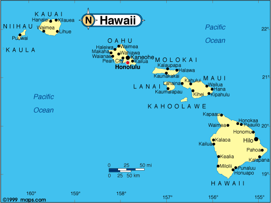 |
This Hawai`i base map highlights the location of the state capitol,
Honolulu on the island
of Oahu, and other major cities throughout the state. Hawai`i is the only state of its kind, a chain (the
world's longest) of islands located about 2,400 miles southwest of California in the North Pacific Ocean.
The Hawai`ian chain of 132 islands is 1,532 miles long, though when we think of the state, we usually think of the eight largest islands. Only seven of the Hawai`ian islands are suitable for human habitation. |
| Hawai`i base map, Courtesy of Maps.com. |
|
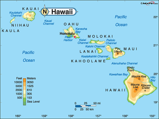 |
This elevation map of Hawai`i illustrates the number of feet or meters the
state rises above sea level. As you can see, most of Hawaii resides at over 2,000 feet above sea level. In fact
the mean elevation of Hawai`i is 3,030 feet above sea level. It
ranks tenth among the 50 states.
Of course, the lowest points in Hawai`i are sea level at the Pacific Ocean. The highest point in the state is located in Hawai`i County on the island of Hawai`i, the big island. Mauna Kea rises 13,796 feet above sea level in the northeastern part of the island, about 99 miles west of Hilo. It's surrounded by Mauna Kea Forest Reserve [ Topographic map ] |
| Hawai`i elevation map, Courtesy of Maps.com. |
Additional information
Hawai`i maps: Additional maps and map links from NETSTATE.COM.
Hawai`i geography: More Hawai`i geography from NETSTATE.COM.
State elevations: State elevations listed by mean elevation, state high point and state low point.
Purchase Hawai`i maps:
Maps.com - The World's Largest Maps Store!
- Select map type by clicking on "category" to left on destination page.
- Use code NETSTATE at the checkout for 10% off orders of $50 or more!
- Over 6,000 products to choose from!
Site designed exclusively for NETSTATE.COM by NSTATE, LLC

NETSTATE.COM is a Trademark of NSTATE, LLC.
Copyright © © by NSTATE, LLC. All rights reserved.
No copyright is claimed on non-original or licensed material.
Support NETSTATE