
HOME
INTRO
SYMBOLS
ALMANAC
ECONOMY
GEOGRAPHY
STATE MAPS
PEOPLE
COUNTIES
GOVERNMENT
FORUM
NEWS
COOL SCHOOLS
STATE QUIZ
STATE LINKS
BOOK STORE
MARKETPLACE
NETSTATE.STORE
NETSTATE.MALL
GUESTBOOK
CONTACT US


Tweet
Double click on word for definition.
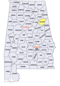
Calhoun County Location
View Larger Map
The map to the right shows the location of Calhoun County within the State of Alabama.
Calhoun County is located in the northeastern area of the state within the Appalachian Valley and Ridge physiographic region. The Coosa River runs along the western edge of the county.
Benton County (now Calhoun County) was established by an Act of the Alabama legislature on December 18, 1832. The county was named for Missouri Senator Thomas Hart Benton. The name was later changed to Calhoun County for South Carolina's secessionist politician and political theorist John C. Calhoun. Calhoun served as a State Representative, State Senator and 7th Vice President. He also held a career-long desire to hold the office of President of the United States.
Initially, Jacksonville, served as the county seat of Calhoun County. The county seat was moved south to Anniston, the "Model City," in 1899.
University of Alabama
Cartographic Research Lab
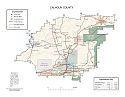
Major roads and towns
Calhoun County Map

Sources...
"Alabama Counties: Calhoun County." Alabama Department of Archives and History. State of Alabama, 25 Oct 2011. Web. 13 Jan 2014. <http://www.archives.state.al.us/counties/calhoun.html>.
Morton, Patricia Hoskins. "Alabama Counties: Calhoun County." Encyclopedia of Alabama. Alabama Humanities Foundation, 7 Nov 2013. Web. 13 Jan 2014. <http://www.encyclopediaofalabama.org/face/Article.jsp?id=h-1198>.
"State & County QuickFacts." United States Census Bureau. United States Department of Commerce. Web. 3 Jan 2014.
Additional Information
Calhoun County history page: Alabama Department of Archives and History.
Calhoun County: The Encyclopedia of Alabama TM & © 2013. Alabama Humanities Foundation. All Rights Reserved. A service of Auburn University, The University of Alabama, and Alabama State Dept. of Education.
Map: Calhoun County's major roads and towns.:
Prepared by the Department of Geography, College of Arts and Sciences, The University of Alabama.
General Highway Map: Calhoun County, Alabama:
Prepared by the Alabama Department of Transportation, Bureau of Transportation Planning, Surveying and Mapping Division in cooperation with the U.S. Department of Transportation.
Calhoun County, Alabama Genealogical Information: The USGenWeb Project: Keeping Internet Genealogy Free.
Calhoun County, Alabama: United States Census Bureau: State & County QuickFacts.
Calhoun County, Alabama: Official website of Calhoun County, Alabama.
Anniston: The Encyclopedia of Alabama TM & © 2013. Alabama Humanities Foundation. All Rights Reserved. A service of Auburn University, The University of Alabama, and Alabama State Dept. of Education.
Anniston, Alabama: Official Site of the City of Anniston, the Model City.
Alabama County Web Sites: State of Alabama: Alabama Directory.
Alabama County Selection Map: United States Census Bureau: State & County QuickFacts.
Alabama County Map with County Seat Cities: Geology.com.
Maps of Alabama Counties: University of Alabama: Alabama Maps.
Alabama Counties from Amazon.com
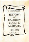
A Chronological History of Benton/Calhoun County, Alabama: 1832 to 1952, by Mickey Stewart. 100 pages. Publisher: M. Stewart (1999)
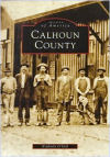
Images of America:
Calhoun County
Kimberly O'Dell
Images of America: Calhoun County, by Kimberly O'Dell. 128 pages. Publisher: Arcadia Publishing (July 1998)
Calhoun County has a diverse and unique history. Chief Ladiga and his Creek tribe first settled in the northeastern half of the county. By the early 1800s, settlers from Georgia, Tennessee, and South Carolina came to this scenic mountainous area to farm in the county’s rich valleys. After the Treaty of Cusseta removed the Creeks west of the Mississippi in 1832, more settlers began arriving. In 1833, Benton County was incorporated into the state of Alabama and Jacksonville was made the county seat. Oxford, or “Lick-Skillet,” was a frontier town at the time, and Piedmont, or “Cross Plains,” was an intersection for the two stagecoach routes. By the time of the Civil War, the county would change its name to Calhoun County in honor of South Carolina statesman John C. Calhoun. In 1872, two northern industrialists, Samuel Noble and Gen. Daniel Tyler, created their “model city” in Anniston, which began a period of great growth in the county.
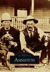
Images of America:
Anniston
Kimberly O'Dell
Images of America: Anniston, by Kimberly O'Dell. 99 pages. Publisher: Arcadia Publishing (October 14, 2000)
Once known as Pine Ankle and sparsely populated with farms, Anniston, Alabama, has seen a multitude of changes over the course of its history. Founded on land that was originally home to Native Americans, the town was created by Samuel Noble and General Daniel Tyler as a “model city” for their Woodstock Iron Company in 1872, and not opened to the public until 1883. Rapid growth in the late nineteenth century brought not only new industries to the area but also Anniston’s designation as seat of Calhoun County and an expansion of the entire downtown area. The vintage photographs within these pages reveal what life was like in Anniston in days gone by, highlighting key figures in the town’s development as well as the everyday people who have lived and worked in the community for generations. Readers will discover the new industries that sprang up after the Oxford Iron Furnace was burned by Union forces in 1865, and the effects of the population boom of the late nineteenth century. Anniston’s homes, schools, and churches are featured in this pictorial retrospective, as well as the town’s role as an important military site, with Camp Shipp, Fort McClellan, Pelham Range, and the Anniston Ordinance Depot all located within the town’s vicinity over the past century.


