
HOME
INTRO
SYMBOLS
ALMANAC
ECONOMY
GEOGRAPHY
STATE MAPS
PEOPLE
COUNTIES
GOVERNMENT
FORUM
NEWS
COOL SCHOOLS
STATE QUIZ
STATE LINKS
BOOK STORE
MARKETPLACE
NETSTATE.STORE
NETSTATE.MALL
GUESTBOOK
CONTACT US


Tweet
Double click on word for definition.
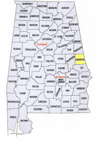
Chambers County Location
View Larger Map
The map to the right shows the location of Chambers County within the State of Alabama.
Chambers County is located in eastern Alabama within the Piedmont Upland physiographic region. The Chattahoochee River travels along its eastern border with the State of Georgia.
Chambers County was established by and Act of the Alabama Legislature on December 18, 1832.
The county was named for Alabama physician, planter, and politician Henry H. Chambers. Elected to the U.S. Senate in 1825, Senator Chambers was never to serve. He died in Virginia on the way to Washington, D.C.
A location for the county seat, in the center of the county, was selected in 1833. It was at that location that LaFayette was built, expressly to serve as the county seat.
University of Alabama
Cartographic Research Lab
Major roads and towns
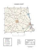
Chambers County Map

Sources...
"Alabama Counties: Chambers County." Alabama Department of Archives and History. State of Alabama, 19 Nov 2009. Web. 16 Jan 2014. <http://www.archives.state.al.us/counties/chambers.html>.
Morton, Patricia Hoskins. "Alabama Counties: Chambers County." Encyclopedia of Alabama. Alabama Humanities Foundation, 25 Nov 2013. Web. 16 Jan 2014. <http://www.encyclopediaofalabama.org/face/Article.jsp?id=h-1305>.
"State & County QuickFacts." United States Census Bureau. United States Department of Commerce. Web. 3 Jan 2014.
Additional Information
Chambers County history page: Alabama Department of Archives and History.
Chambers County: The Encyclopedia of Alabama TM & © 2013. Alabama Humanities Foundation. All Rights Reserved. A service of Auburn University, The University of Alabama, and Alabama State Dept. of Education.
Map: Chambers County's major roads and towns.:
Prepared by the Department of Geography, College of Arts and Sciences, The University of Alabama.
General Highway Map: Chambers County, Alabama:
Prepared by the Alabama Department of Transportation, Bureau of Transportation Planning, Surveying and Mapping Division in cooperation with the U.S. Department of Transportation.
Chambers County, Alabama Genealogical Information: The USGenWeb Project: Keeping Internet Genealogy Free.
Chambers County, Alabama: United States Census Bureau: State & County QuickFacts.
Chambers County, Alabama: Official website of Chambers County, Alabama.
LaFayette: The Encyclopedia of Alabama TM & © 2013. Alabama Humanities Foundation. All Rights Reserved. A service of Auburn University, The University of Alabama, and Alabama State Dept. of Education.
LaFayette, Alabama: Official Site of the City of LaFayette.
Alabama County Web Sites: State of Alabama: Alabama Directory.
Alabama County Selection Map: United States Census Bureau: State & County QuickFacts.
Alabama County Map with County Seat Cities: Geology.com.
Maps of Alabama Counties: University of Alabama: Alabama Maps.
Alabama Counties from Amazon.com
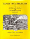
Heart Pine Straight
William H. Davidson
Heart Pine Straight: Houses and people of Chambers County, Alabama, by William H. Davidson. 257 pages. W.H. Davidson; 1st edition (1998)
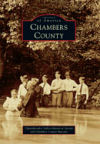
Images of America:
Chambers County
Images of America: Chambers County, Chambers County Museum, Chattahoochee Valley Historical Society. 128 pages. Publisher: Arcadia Publishing (November 1, 2010)
Chambers County, created in 1832, embraces the southernmost hills and streams of the Piedmont Plateau and sections of the Chattahoochee River to the east and the Tallapoosa River to the west. Cotton cultivation and textile manufacturing propelled the trajectory of the first 150 years in the county. Images of America: Chambers County presents an array of images of places and people who began life on the frontier, created local government, experienced Native American uprising, served in the Civil War and two world wars, cultivated thousands of productive acres with ox and mule, organized towns, constructed railroads, and built one of the nation’s largest textile operations. This bounty of photographs, most of which was provided from family collections, furthers an understanding of the unique story of Chambers County in the ongoing development of the American experience.


