
HOME
INTRO
SYMBOLS
ALMANAC
ECONOMY
GEOGRAPHY
STATE MAPS
PEOPLE
COUNTIES
GOVERNMENT
FORUM
NEWS
COOL SCHOOLS
STATE QUIZ
STATE LINKS
BOOK STORE
MARKETPLACE
NETSTATE.STORE
NETSTATE.MALL
GUESTBOOK
CONTACT US


Tweet
Double click on word for definition.
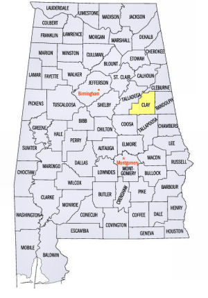
Clay County Location
View Larger Map
The map to the right shows the location of Clay County within the State of Alabama.
Clay County is located in east central Alabama within the Piedmont Upland physiographic region. About 1/3 of the county, from the northeastern to the southwestern corners, lies within the Talladego National Forest.
Clay County was established by an Act of the Alabama Legislature on December 7, 1866.
The county was named for United States Senator Henry Clay, of Kentucky.
Ashland, located in the east central part of the county, serves as the county seat of Clay County. Ashland is named after the Kentucky Home of Henry Clay.
University of Alabama
Cartographic Research Lab
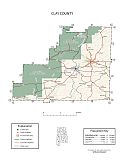
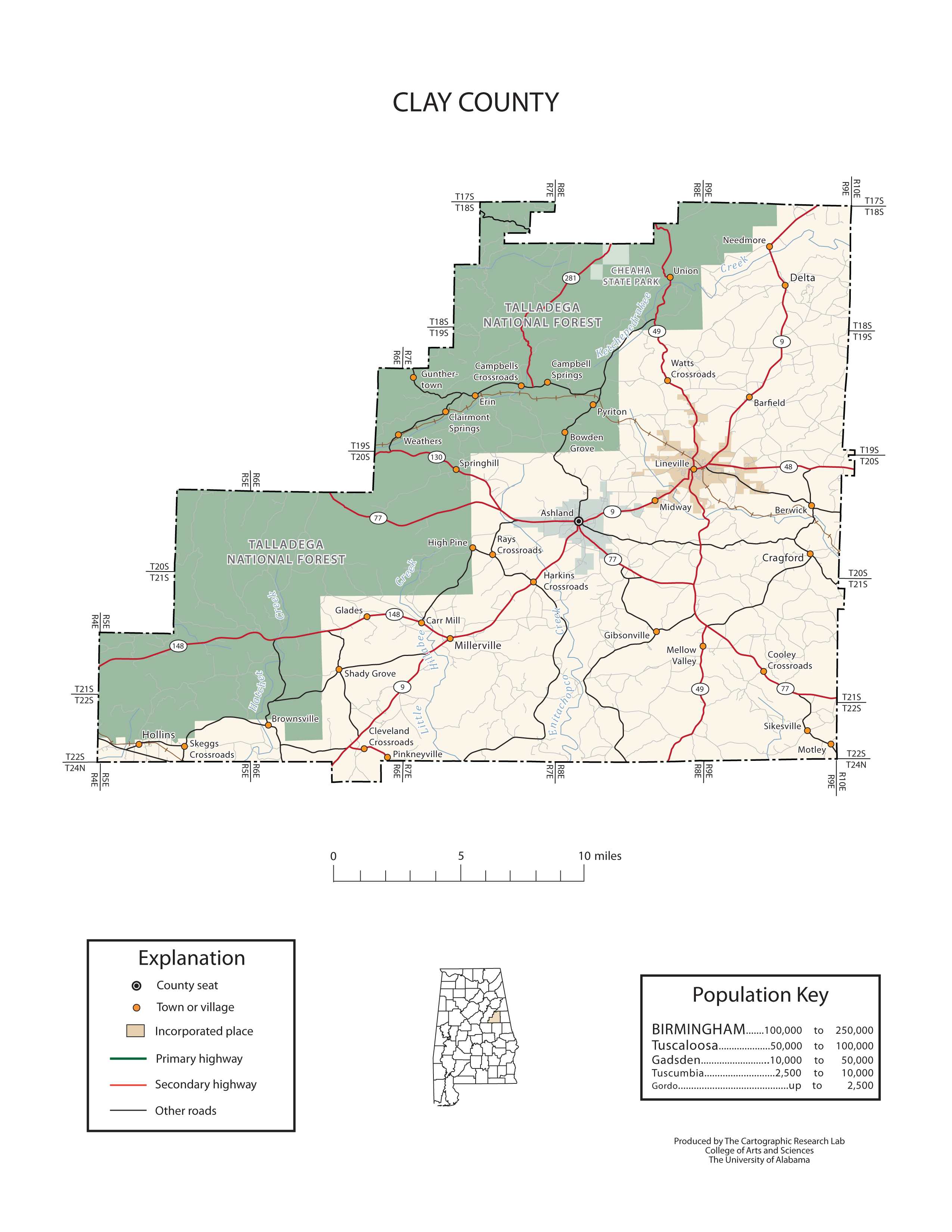
Major roads and towns
Clay County Map

Sources...
"Alabama Counties: Clay County." Alabama Department of Archives and History. State of Alabama, 19 Nov 2009. Web. 19 Jan 2014. <http://www.archives.state.al.us/counties/clay.html>.
Morton, Patricia Hoskins. "Alabama Counties: Clay County." Encyclopedia of Alabama. Alabama Humanities Foundation, 22 Mar 2013. Web. 19 Jan 2014. <http://www.encyclopediaofalabama.org/face/Article.jsp?id=h-1205>.
"State & County QuickFacts." United States Census Bureau. United States Department of Commerce. Web. 3 Jan 2014.
Additional Information
Clay County history page: Alabama Department of Archives and History.
Clay County: The Encyclopedia of Alabama TM & © 2013. Alabama Humanities Foundation. All Rights Reserved. A service of Auburn University, The University of Alabama, and Alabama State Dept. of Education.
Map: Clay County's major roads and towns.:
Prepared by the Department of Geography, College of Arts and Sciences, The University of Alabama.
General Highway Map: Clay County, Alabama:
Prepared by the Alabama Department of Transportation, Bureau of Transportation Planning, Surveying and Mapping Division in cooperation with the U.S. Department of Transportation.
Clay County, Alabama Genealogical Information: The USGenWeb Project: Keeping Internet Genealogy Free.
Clay County, Alabama: United States Census Bureau: State & County QuickFacts.
Clay County,Alabama: Wikipedia, the free encyclopedia.
Ashland: The Encyclopedia of Alabama TM & © 2013. Alabama Humanities Foundation. All Rights Reserved. A service of Auburn University, The University of Alabama, and Alabama State Dept. of Education.
Ashland, Alabama: Official Site of the City of Ashland, city of friends.
Alabama County Web Sites: State of Alabama: Alabama Directory.
Alabama County Selection Map: United States Census Bureau: State & County QuickFacts.
Alabama County Map with County Seat Cities: Geology.com.
Maps of Alabama Counties: University of Alabama: Alabama Maps.
Alabama Counties from Amazon.com
History of
Clay County, Alabama
History of Clay County, Alabama, Clay County Historical Society. 99 pages. Publisher: Clay County Historical Society (1999)

You Always
Think of Home:
A Portrait of
Clay County, Alabama
Pamela Grundy
You Always Think of Home: A Portrait of Clay County, Alabama, by Pamela Grundy. 304 pages. Publisher: University of Georgia Press (April 1991)
You Always Think of Home is a collective memoir of Clay County, Alabama, and the people who live/lived there. It consists of excerpts from interviews with residents recorded between May 1987 and June 1988. Grundy has done an outstanding job of portraying varying perspectives of life in this rural county which remains filled with people who are genuinely concerned for one another's well-being. While times have changed, the book brings clearly into focus a treasured way of life which continues to exist today in this area.
The book is topically arranged with introductory notes to each topic. All interviews were approved and some corrected by the interviewee.
The portrait that emerges, while not idyllic, is certainly one of peace and serenity. Clay County seems to have been mostly untouched by the strife that has beset the rest of the South.


