
HOME
INTRO
SYMBOLS
ALMANAC
ECONOMY
GEOGRAPHY
STATE MAPS
PEOPLE
COUNTIES
GOVERNMENT
FORUM
NEWS
COOL SCHOOLS
STATE QUIZ
STATE LINKS
BOOK STORE
MARKETPLACE
NETSTATE.STORE
NETSTATE.MALL
GUESTBOOK
CONTACT US


Tweet
Double click on word for definition.
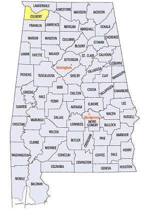
Colbert County Location
View Larger Map
The map to the right shows the location of Colbert County within the State of Alabama.
Colbert County is located in the northwest corner Alabama within, for the most part, the Highland Rim physiographic region. A small part of southwestern Colbert County is defined by the East Gulf Coastal Plain. The county is bordered by the State of Mississippi on the west. The Tennessee River runs along the northern border of Colbert County.
First it was and then it wasn't and then it was! Colbert County was established from a portion of Franklin County, by an Act of the Alabama State Legislature on December 7, 1867. Politically motivated, this occurred during the turbulent era of Reconstruction after the Civil War. Nine months later, the act was repealed by the legislature and Colbert County was no more until, in January 1870, controversial, Reconstruction Governor William Smith nullified the action. Colbert County was back.
The county was named for named for Chickasaw tribal leaders George and Levi Colbert who operated a ferry crossing on the Tennessee River.
Tuscumbia, birthplace of Helen Keller, is located near the Tennessee River on the northern edge of Colbert County. Tuscumbia was called Occocopoosa when it was incorporated in 1820. It was renamed Big Spring in 1821 and, finally, Tuscumbia in 1822.
University of Alabama
Cartographic Research Lab
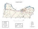
Major roads and towns
Colbert County Map

Sources...
Thornton, Linda. "Tuscumbia." Encyclopedia of Alabama. Alabama Humanities Foundation, 20 Jun 2013. Web. 20 Jan 2014. <http://www.encyclopediaofalabama.org/face/Article.jsp?id=h-1318>.
"Alabama Counties: Colbert County." Alabama Department of Archives and History. State of Alabama, 20 Nov 2009. Web. 20 Jan 2014. <http://www.archives.state.al.us/counties/colbert.html>.
Morton, Patricia Hoskins. "Alabama Counties: Colbert County." Encyclopedia of Alabama. Alabama Humanities Foundation, 22 Mar 2013. Web. 20 Jan 2014. <http://www.encyclopediaofalabama.org/face/Article.jsp?id=h-1318>.
"State & County QuickFacts." United States Census Bureau. United States Department of Commerce. Web. 3 Jan 2014.
Additional Information
Colbert County history page: Alabama Department of Archives and History.
Colbert County: The Encyclopedia of Alabama TM & © 2013. Alabama Humanities Foundation. All Rights Reserved. A service of Auburn University, The University of Alabama, and Alabama State Dept. of Education.
Map: Colbert County's major roads and towns.:
Prepared by the Department of Geography, College of Arts and Sciences, The University of Alabama.
General Highway Map: Colbert County, Alabama:
Prepared by the Alabama Department of Transportation, Bureau of Transportation Planning, Surveying and Mapping Division in cooperation with the U.S. Department of Transportation.
Colbert County, Alabama Genealogical Information: The USGenWeb Project: Keeping Internet Genealogy Free.
Colbert County, Alabama: United States Census Bureau: State & County QuickFacts.
Colbert County, Alabama: Official website of Colbert County, Alabama.
Tuscumbia: The Encyclopedia of Alabama TM & © 2013. Alabama Humanities Foundation. All Rights Reserved. A service of Auburn University, The University of Alabama, and Alabama State Dept. of Education.
Tuscumbia, Alabama: Official Site of the City of Tuscumbia, charm of the shoals.
Alabama County Web Sites: State of Alabama: Alabama Directory.
Alabama County Selection Map: United States Census Bureau: State & County QuickFacts.
Alabama County Map with County Seat Cities: Geology.com.
Maps of Alabama Counties: University of Alabama: Alabama Maps.
Alabama Counties from Amazon.com
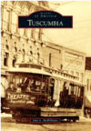
Images of America:
Tuscumbia
John L. McWilliams
Images of America: Tuscumbia, by John L. McWilliams. 128 pages. Publisher: Arcadia Publishing (January 9, 2012)
Tuscumbia sits at the foothills of the Appalachian Mountains in northwest Alabama in an area known as the Shoals. The area is rich with history beginning with the Native Americans who lived near the big spring for thousands of years. The European influence began with the Spanish under De Soto and the French, who had a trading post here in the 1700s. In the early 1800s, the African American influence became prevalent. Tuscumbia was America’s first frontier railroad town with the incorporation of Tuscumbia Railroad Company and the home of “America’s First Lady of Courage,” Helen Keller. Today, Tuscumbia contains the oldest commercial buildings in the state of Alabama. Rail service was expanded in 1834 around the treacherous Muscle Shoals of the Tennessee River between Florence and Decatur, connecting steamboats at Tuscumbia Landing with Decatur, Alabama. Thousands of Native Americans—Cherokee, Creek, and Chickasaw—were removed from Tuscumbia to their new home in Indian Territory.


