
HOME
INTRO
SYMBOLS
ALMANAC
ECONOMY
GEOGRAPHY
STATE MAPS
PEOPLE
COUNTIES
GOVERNMENT
FORUM
NEWS
COOL SCHOOLS
STATE QUIZ
STATE LINKS
BOOK STORE
MARKETPLACE
NETSTATE.STORE
NETSTATE.MALL
GUESTBOOK
CONTACT US


Tweet
Double click on word for definition.
Coosa County Location
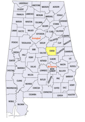
View Larger Map
The map to the right shows the location of Coosa County within the State of Alabama.
Coosa County is located in east-central Alabama within the Piedmont Upland physiographic region. The Coosa River forms the county's western border.
Coosa County was established by an Act of the Alabama State Legislature on December 8, 1832. It was created from land ceded by the Creek Indians in the March 24, 1832 Treaty of Cusseta.
The county was named for the Coosa River.
Rockford, located in south-central Coosa County, serves as the county seat. The site on Hatchemalega (Hatchet) Creek was originally named Lexington. In 1835, Lexington was renamed Rockford.
University of Alabama
Cartographic Research Lab
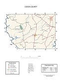
Major roads and towns
Coosa County Map

At a glance
| Category | Information |
|---|---|
| Established: | December 18, 1832 |
| Source: | Created from ceded Indian lands in 1832. |
| Area (square miles): | 657 |
| Population (2010 census): | 11,539 |
| Major waterway(s): | The Coosa River is one of the most developed rivers in Alabama. Approximately 280 miles long, the Coosa River begins in Rome, Georgia and meanders about 28 miles west until it crosses into Alabama. Flowing approximately 252 miles through Alabama, the Coosa joins the Tallapoosa River, just south of Wetumpka, to form the Alabama River. The Coosa River gives Coosa County its name and defines the western border of the county on its way to Montgomery. |
| Major highway(s): | U.S. Route 280, U.S. Route 231. |
| County seat: | Rockford |
| Largest city: | Goodwater |
Sources...
"Alabama Counties: Coosa County." Alabama Department of Archives and History. State of Alabama, 20 Nov 2009. Web. 21 Jan 2014. <http://www.archives.state.al.us/counties/coosa.html>.
Morton, Patricia Hoskins. "Alabama Counties: Coosa County." Encyclopedia of Alabama. Alabama Humanities Foundation, 21 Mar 2013. Web. 21 Jan 2014. <http://www.encyclopediaofalabama.org/face/Article.jsp?id=h-1313>.
"State & County QuickFacts." United States Census Bureau. United States Department of Commerce. Web. 3 Jan 2014.
Additional Information
Coosa County history page: Alabama Department of Archives and History.
Coosa County: The Encyclopedia of Alabama TM & © 2013. Alabama Humanities Foundation. All Rights Reserved. A service of Auburn University, The University of Alabama, and Alabama State Dept. of Education.
Map: Coosa County's major roads and towns.:
Prepared by the Department of Geography, College of Arts and Sciences, The University of Alabama.
General Highway Map: Coosa County, Alabama:
Prepared by the Alabama Department of Transportation, Bureau of Transportation Planning, Surveying and Mapping Division in cooperation with the U.S. Department of Transportation.
Coosa County, Alabama Genealogical Information: The USGenWeb Project: Keeping Internet Genealogy Free.
Coosa County, Alabama: United States Census Bureau: State & County QuickFacts.
Coosa County: National Association of Counties (NACO).
Autauga County Commission: Official website of Coosa County, Alabama.
Rockford: The Encyclopedia of Alabama TM & © 2013. Alabama Humanities Foundation. All Rights Reserved. A service of Auburn University, The University of Alabama, and Alabama State Dept. of Education.
Rockford, Alabama: Entry for Rockford at Wikipedia, the free encyclopedia.
Alabama County Web Sites: State of Alabama: Alabama Directory.
Alabama County Selection Map: United States Census Bureau: State & County QuickFacts.
Alabama County Map with County Seat Cities: Geology.com.
Maps of Alabama Counties: University of Alabama: Alabama Maps.
Alabama Counties from Amazon.com


