
| Suggest a link | |
| Report broken link |


New Jersey Base and Elevation Maps
The two maps shown here are digital base and elevation maps of New Jersey. Higher resolution maps like
these and many other digital maps, wall maps, custom radius maps, travel maps, travel guides, map software, and globes and
games, for business and the classroom, are available to purchase from
Maps.com - The World's Largest Maps Store!.
Enter code "NETSTATE" at checkout for 10% off orders of $50 or more!
 |
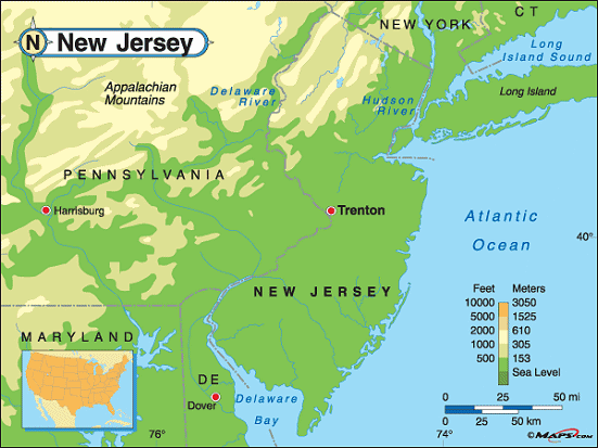
This New Jersey base map highlights the location of the state capitol,
Trenton, and
major cities throughout the state. Portions of New Jersey's border states,
New York,
Delaware, and
Pennsylvania are
included to show the relationship between New Jersey and its neighbors. A small inset shows New Jersey among the
other 47 Continental United States.
The eastern border of New Jersey is defined by the Hudson River in the north and the Atlantic Ocean in the south. The western border is defined by the Delaware River and Delaware Bay. |
| New Jersey base map, Courtesy of Maps.com. |
|
 |
This elevation map of New Jersey illustrates the number of feet or meters the
state rises above sea level. As you can see, most of New Jersey resides at, or less than 500 feet above,
sea level. From sea level at the Atlantic Coast and Delaware Bay, the land rises to the northwest of the state.
The highest point in New Jersey, High Point, rises 1,803 feet above sea level. It's located in the northwest corner of New Jersey, just south of Port Jervis, New York, in Montague, Sussex County. High Point is found in the Kittatinny Mountain Range, part of the Appalachian Mountains. [ Satellite ] |
| New Jersey elevation map, Courtesy of Maps.com. |
Additional information
New Jersey maps: Additional maps and map links from NETSTATE.COM.
New Jersey geography: More New Jersey geography from NETSTATE.COM.
Purchase New Jersey maps:
Maps.com - The World's Largest Maps Store!
- Select map type by clicking on "category" to left on destination page.
- Use code NETSTATE at the checkout for 10% off orders of $50 or more!
- Over 6,000 products to choose from!
Site designed exclusively for NETSTATE.COM by NSTATE, LLC

NETSTATE.COM is a Trademark of NSTATE, LLC.
Copyright © © by NSTATE, LLC. All rights reserved.
No copyright is claimed on non-original or licensed material.
Support NETSTATE